SATELLITE LEAK DETECTION FOR WATER UTILITIES
Send your crews
straight to the leaks.
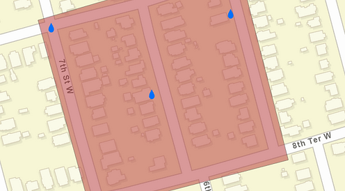
Paradigm uses synthetic aperture radar to flag where hidden leaks are located, then delivers those areas straight into ArcGIS Online and Field Maps for your team to investigate.
Built by water loss professionals, for water utilities.
187M+
gallons of water loss addressed
$1.5M+
in retail water value recovered
100+
leaks located across multiple programs
From orbit to repair in three steps
1
Identify & Prioritize
Our satellite derived algorithm and risk model flag hidden leaks, then deliver prioritized areas of investigation straight to your ArcGIS Field Map.
2
Pinpoint in the Field
Your technicians confirm each area with acoustic listening devices and data loggers, guided by Field Maps, and mark leak locations as they go.
3
Repair & Report
Crews fix confirmed leaks before they become emergencies, and we report water loss addressed and financial impact using AWWA M36 methods.
Proven in the field
✓
Arlington Water Utilities
"When we tested Paradigm, 7 out of 10 points of interest had leaks." Paradigm has since helped the city locate 33 leaks and save $36,617 in energy costs.
✓
Municipal Texas Utility
A 12-month program: 120 prioritized areas led to 50 leaks found and repaired, addressing an estimated 121M gallons of water loss and $907K in retail water value.
✓
Large Metro Texas Utility
A targeted program: 40 prioritized areas led crews to 17 hidden leaks, addressing an estimated 66M gallons of water loss and $609K in retail water value.
Water loss and financial estimates follow AWWA M36 methods with conservative 182.5-day leak runtimes. Some utility names withheld for confidentiality.